www.Muggaccinos.com The Bullsheet
Sunday,
29 July '07,
8:05am
from Jersey St carpark Hornsby to St Ives carpark
for
8:30am rollout from St Ives “Whale Beach for Brunch,
Palm Beach loop, Akuna Bay cafe for Lunch”
- ETR 1:55pm:
* 89.4km
(from St Ives)
via the Roller Coaster from Hell - 10
min Sag Stop at Church Point; or
* 85km
(from St Ives)
up flat main
beach road - 20 mins faster leg - 20 min Sag Stop at Church Point
-
Ride Organiser: Phil Johnston aka Scribe - 9114.6689 VOIP
-
Hardcopy this Ride Description and spend 5 min reviewing your UBD
Final section of our route to Whale Beach offers two options. After Sag Stop at Church Point, either -
* HILLY - Newport Arms/Clareville/Careel Bay. This hilly route now avoids the 'killer' 600m 21.4o climb up Loombah St by turning R at Herbert Ave. The peak gradient is now only 17.4o in Cheryl Cres, but it remains a demanding ride leg requiring a triple or massive quads; or
* EASY - up main beach road by turning Left into Darley St and then Left into Barrenjoey Rd past Bungan Beach, Newport, Bilgola, Avalon and Right into Whale Beach RdWeaker riders, or those without a very low gears, may opt to ride on the main beach road which is relatively flat, but busier.
Cycle two abreast on single lane roads at own risk, and never ride two abreast with a unbroken centre line
Keep well to LHS of the road and get off the road at Sag Stops
-
Don't cross 3 lanes of traffic at lights at McCarrs Creek Rd back onto Mona Vale Rd. Rather return along Larool Rd, or use the tunnel under Mona Vale Rd
-
Click on: Risk Warnings which warns of the dangers of cycling on public roads with motor cars, potholes and over bridges with vertical timber planks with gaps
Snapshot:
8:05am rollout Hornsby station carpark in Jersey St (300m NW of Hornsby station in Jersey St) to St Ives car park on Mona Vale Rd [opposite Pattisons Patisserie and Stanley St. junction] for 8:30am rollout for 6.5km to Terrey Hills Fruit Barn Sag Stop (3 min).
Descend McCarrs Creek Rd to Church Point Nosh Stop (10 or 20 min depending on whether U ride Hilly or Easy route to Whale Beach).
L into Mona St and L via Newport Arms Hotel / Clareville / Careel Bay for 1st Nosh Stop at 10:35am [43km] at Whale Beach Café.
[Or turn L (one road after Mona St) into Darley Rd and L 700m later into Barrenjoey Rd for 9km up main beach road and turn R into Whale Beach Rd - 35km] arriving from 10:25am.
Return along Barrenjoey Rd to top of Avalon golf course, L for 3km back-road thru The Serpentine returning to Barrenjoey Rd at Sth Bilgola Beach with [64km] at Akuna Bay Café at 12:30pm - ETR St Ives 1:55pm.
SagStops:
1st: Terrey Hills Fruit Barn (3 min) from 8:50am
2nd: Church Point from 9:20am
3rd: Serpentine lookout Bilgola Beach (10 min) at 11:15am
NoshStops:
1st: Whale Beach Café (35 min) from -
10:25am for cyclists who ride Barrenjoey Rd; and
10:35am for cyclists on Roller Coaster from Hell
2nd: Akuna Bay café (30 min) from 12:30pm
KOM Climb:
TollBooth at Illawong Bay past Cottage Pt Rd to TollBooth at entrance
Prologue Leg: Hornsby Jersey St carpark to St Ives carpark - 6.5km - 15 min
8:05am cycle -
L
Jersey St
0.2
Roundabout.
A
Station St
0.2
Old Pacific H'way
L
Old Pacific H'way
0.3
Leonard St
L
Leonard St / Pattison Ave
0.2
Alexandria Pde/Millewa Ave
L
Alexandria Pde/Millewa Ave
2.9
Bangalla St
L
Bangalla St
0.7
Eastern Rd
R
Eastern Rd
0.3
Brentwood/Boomerang Ave
L
Brentwood/Boomerang Ave
2.1
Mona Vale Rd
L
Mona Vale Rd
0.7
St Ives car park
1st
Leg:
St Ives to
Church Point -
20km - 35 min
8:30am cycle -
-
E along Mona Vale Rd for 6.6km;
-
L [opposite Forest Way - at Mona Vale Fruit Barn] into Myoora Rd and take a 1st Sag Stop (3 min) - don't cluster at Sag Stop, rather spread thin to get well to LHS of Myoora Rd;
-
Ahead along Myoora Rd for 300m;
-
Ahead into Larool Rd for 2.9km
-
R into Booralie Rd for 300m passing Terrey Hills shops and roundabout;
-
L to McCarrs Creek Rd descend 2.2km into the park - to the V (dual entrances to the park);
-
R fork and pedal 2.8km descending McCarrs Creek Rd to McCarrs Creek bridge;
-
Ahead 5.5km along McCarrs Creek Rd to Church Point [20km] at 9:35am 2nd Sag Stop (5 min if cycling 1st option below or 20 mins if cycling 2nd option below) - Be ready to roll out promptly if you are cycling the 1st option immediately below;
2nd Leg - 2 options from Church Point to Whale Beach:
* 1st option - 23.5km via the Roller Coaster from Hell, where you need a triple chain ring or humongous quads
* 2nd option - 15km flat route up the main beach road
1st option: Roller Coaster from Hell: Church Point to Whale Beach Café - 23.5km - 70 min
9:30am -
-
East twds Mona Vale for 3½km - road becomes Pittwater Rd past Cabbage Tree Rd (on RHS) to Darley St - 500m short of Mona Vale shops;
-
Left into Mona St for 850m;
-
Right into Waterview St for 750m;
-
Left into Crescent Rd for 1.6km of ‘whirly burly’ ‘roller coaster’;
-
Left into Beaconsfield St for 400m;
-
Right into Kalinya St for 220m;
-
Right into Gladestone St for 200m;
-
Left into King St for 400m;
-
Left into Irrubel Rd for 700m;
-
Right into Prince Alfred Ave for 1km;
-
Right into Herbert Ave for 300m;
-
Right into Wallumatta Rd for 1.3km;
-
Left into Cheryl Cres for 1.1km;
-
Right into Raymond Rd for 300m;
-
Left into Terama St for 500m;
-
Left into Lower Plateau Rd for 1.8km;
-
Left into Wandeen Rd for 850m;
-
Right into Hudson Pde for 1.9km;
-
Left into Riverview Rd for 1.9km;
-
Right into Cabarita Rd/Patrick St for 1.7km;
-
Left into Elvina St for 50m;
-
Right into George St for 150m;
-
Left into Barrenjoey Rd for 800m;
-
SignPost R into Whale Beach Rd and ascend/descend for 2.4km to The Strand Rd for 50m to Brekkie 1st Nosh Stop (45 min) from 10:35am [43.5km] at -
* Whale Beach Restaurant 9974.4009 ph on the water’s edge or;
* cafe at top of Surf Rd - 50m before beach.
2nd option - Church Point to Whale Beach - flat route up the main beach road - 15km - 45 min
9:40am -
-
East twds Mona Vale for 3½km - road becomes Pittwater Rd past Cabbage Tree Rd (on RHS) to Darley St - 500m short of Mona Vale shops;
-
Left into Darley St for 700m;
-
Left into Barrenjoey Rd for 9km
-
SignPost R into Whale Beach Rd and ascend/descend for 2.4km to The Strand Rd for 50m to Brekkie 1st Nosh Stop (35 min) at 10:25am [35km] at -
* Whale Beach Cafe 9974.4009 ph on the water’s edge or;
* cafe at top of Surf Rd - 50m before beach.
3rd Leg: Whale Beach to Palm Beach to Akuna Bay Café - 28.7km - 75 min
11:10am -
-
Nth on Whale Beach Rd/Florida Rd/PalmBeach Rd for 3km hugging the coastline to Palm Beach -
-
L Sth onto Barrenjoey Rd for 5.6km passing Avalon Golf Course on RHS;
-
SignPost L into The Serpentine for 3km adjunct into/out of Bilgola Beach which avoids a tight section of Barrenjoey Rd and provides a stunning view south from Serpentine lookout Bilgola Beach 4thSag Stop (10 min) at 11:25am;
-
Ahead along The Serpentine down to/up from Bilgola Beach;
-
L back onto Barrenjoey Rd for 2km passing Newport Beach and climb a short humdinger up Newport hill and take 5thSag Stop (10 min) - lift your bike over the gutter and get off the busy 3 lane road;
-
Ahead 1.5km and passing Bungan Beach on LHS, and approach Mona Vale;
-
R back into Darley St for 700m (wait until it is safe to cross over to R lane);
-
R into Pittwater Rd for 8.5km to Church Point to McCarrs Creek bridge;
-
R into West Head Rd for 1.5km to "T" intersection;
-
L into Liberator General San Martin Drive for 2.8km to Akuna Bay Café for 2nd Nosh Stop (30 min) from 12:30pm.
3rd Leg: Akuna Bay to St Ives - 20.3km - 58 min
At 1pm final leg -
-
West for 8.1km along Liberator General San Martin Drive passing Illawong Bay, Cottage Point Rd, park entrance toll-both to "V" juncture at McCarrs Creek Rd,
-
Ahead for 2.2km to the apex of McCarrs Creek Rd;
-
R into Booralie Rd for 200m;
-
L into Myoora Rd for 3.3km;
-
R into Mona Vale Rd for 6.6km to St. Ives car-park :
* ETR St Ives 1:55pm after 85km if up beach road or 89.4km if Roller Coaster from Hell; or
* ETR St Ives 12:55pm for 81km if you skip Akuna Bay and that Nosh Stop.
NOTE: When almost back at St Ives, after climbing to the apex of McCarrs Creek Rd, either take the tunnel under Mona Vale Rd or retrace along Larool Rd to Terrey Hills Fruit Barn and R at lights onto Mona Vale Rd. Don't enter Mona Vale Rd at lights at McCarrs Creek Rd, as motorists coming from the coast are doing 80+ clicks and aren't impeded by the traffic lights granting us access to Mona Vale Rd.
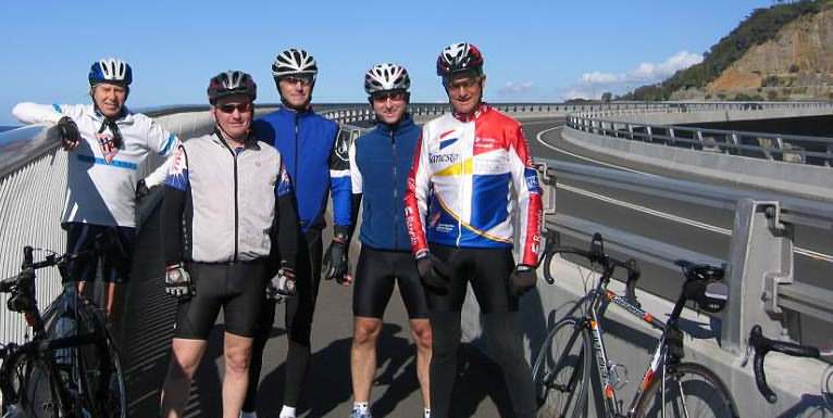
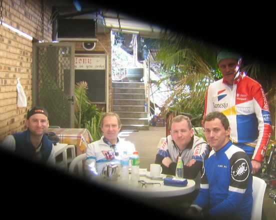
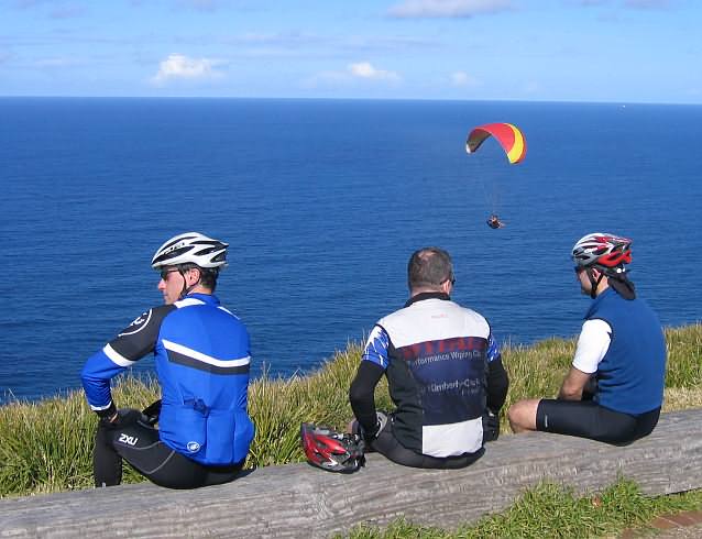
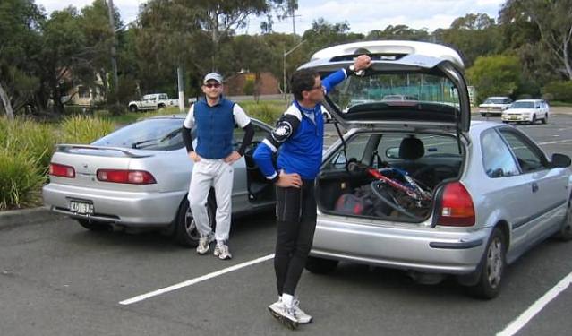
Bank Teller's rap-up of Tour de Austinmer 'n Royal National Park - 94km - 5 cyclists
|
|
|
|
|
|
|
|
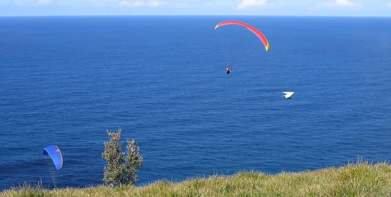
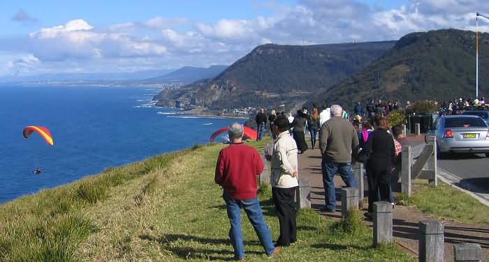
Greg, Matt and Martin joining the throng of sightseers at the Otford Lookout in brill Winter sunlight. Unbeknownst to us the 10km section through the thick woodland forest shortly thereafter proved in stark contrast where the temp plummeted to single figures. |
|
|
|
|
|
|
|
|
|
Scribe 20 July ' 07