www.Muggaccinos.com The Bullsheet
Sunday, 30 July, rollout of St Ives carpark from 8:15am to aboard 10:30am “Ferry from Palm Beach to -
1. Wagstaffe Wharf, McMasters Beach, Avoca Beach, Matcham, Holgate, Lisarow train to Hawkesbury River station at Brooklyn, Hornsby, Nth. Turramurra, St Ives - 117.8km - ETR 4:50pm.
2. Or skip 2 legs (25km of cycling from Brooklyn to Hornsby) by staying on train for 57 min from Lisarow station to Hornsby, reducing ride to 83.6km - ETR 3.26pm
3. Or ride from Ettalong Wharf back to St Ives via Kariong, Calga, Mt White, Hornsby to St Ives - 122km - ETR 3:40pm.
4. Or return from Palm Beach with a Nosh Stop at Bayview Marina - 77km - ETR 1:10pm
-
Click on: Risk Warnings which 'inter alia' warns of the dangers of cycling on public roads with motor cars, potholes and over bridges with vertical timber planks with gaps
-
Hardcopy ride description from 109 or 84 or 77 at "Ride Calendar 2006 - July to Sept" and bring on Sunday
-
Check your tyres for punctures before you arrive, 'cause we catch the 10:30am ferry from Palm Beach, so don't screw around getting started, otherwise you won't have time to buy grits 'n swill before aboarding the ferry boat
-
If you are delayed, you could opt to stay on flattish Barrenjoey Rd to Palm Beach Wharf, rather than taking Right past Avalon Rd up hilly Whale Beach Rd, reducing ride time by 15 mins
-
No SRA track work on train line between Wyong and Hornsby this Sunday
-
Ride Organiser: Phil Johnston - 9513.9532
-
Peruse your UBD which will highlight that our route from Wagstaffe hugs the lower Central Coast and veers left adjacent to Gosford delivering us just Nth of Gosford to the quieter suburb of Lisarow
-
Never cycle two abreast on a single lane road with an unbroken centre line, 'cause RTA deems those sections provide inadequate visibility for a motorist to overtake an vehicle ahead.
-
Maintain your membership of Bicycle NSW for $20m Public Liability cover in case you cause a serious accident and another Mugg sues you for riding negligence
|
Depending on your ride speed, between 8:15am
and 8:25am rollout
St Ives car park Mona Vale Rd -
opposite
Pattisons Patisserie
and Stanley St.
If a flat tyre delays you, you could stay on flattish
Barrenjoey Rd
to Palm Beach Wharf, rather than hilly Whale Beach Rd, reducing ride time by
12/15 mins.
SagStops: |
1st Leg: St Ives to Church Point - 20.4km - 45 min
Between 8:15am and 8:25am cycle -
-
E along Mona Vale Rd for 6.6km;
-
L [opposite Forest Way - at Mona Vale Fruit Barn] into Myoora Rd and take a 1st Sag Stop (5 min) - don't cluster at Sag Stop, rather spread thin to get well to LHS of Myoora Rd;
-
Ahead along Myoora Rd for 200m, and fork right, still Myoora Rd for 2.9km
-
R into Booralie Rd for 300m passing Terrey Hills shops and roundabout;
-
L to McCarrs Creek Rd and descend 2.2km into the park - to the V (dual entrances to the park);
-
R fork and pedal 2.8km descending McCarrs Creek Rd to McCarrs Creek bridge;
-
Ahead 5.5km along McCarrs Creek Rd to Church Point at 9:10am 2nd Sag Stop (10 min) - Be ready to roll out promptly;
2nd Leg: Church Point to Palm Beach - 18.3km - 49 min (agg 38.7km)
9:20am -
-
East twds Mona Vale for 3½km - road becomes Pittwater Rd past Cabbage Tree Rd (on RHS) to Darley St - 500m short of Mona Vale shops;
-
L into Darley St and pull-up 40m along 3rd Sag Stop (5 min);
-
Ahead along Darley St for 670m;
-
L into busy Barrenjoey Rd for 7km of views of the Blue Pacific past Bungan Beach thru Newport, Bilgola, Avalon to Whale Beach Rd - 150m past North Avalon Rd;
-
SignPost R into Whale Beach Rd and ascend/descend for 6km passing Whale Beach and continue along the coastal road to Palm Beach and around to the Wharf on the bay side arriving to purchase some grits and embark 10:30am ferry to Wagstaffe Wharf for 1st Nosh Stop (30 min) on the ferry boat.
3rd Leg: Wagstaffe Wharf to Lisarow station - 37km - 116 min (agg 75.6km)
11am -
|
dir |
road name |
dist |
|
grad |
dir |
agg km |
min |
ride |
|
|
A |
Carpark lane |
0.1 |
Wagstaffe Ave |
~ |
SE |
38.8 |
1.0 |
2:46 |
|
|
L |
Wagstaffe Ave |
0.5 |
Pretty Beach Rd |
~ |
E |
39.2 |
1.0 |
2:47 |
|
|
R |
Pretty Beach Rd |
1.0 |
Heath Rd |
~ |
E |
40.2 |
2.0 |
2:49 |
|
|
R |
Heath Rd |
2.2 |
Killcare Rd |
~ |
NE |
42.4 |
6.0 |
2:55 |
|
|
R |
Killcare Rd |
0.4 |
The Scenic Rd |
~ |
NE |
42.8 |
1.1 |
2:56 |
|
|
L |
The Scenic Rd |
0.5 |
Wards Hill Rd |
~ |
NE |
43.3 |
1.5 |
2:57 |
|
|
A |
The Scenic Rd |
1.3 |
Marie Byles Lookout |
/ |
NE |
44.6 |
3.6 |
3:01 |
|
|
|
5th Sag Stop |
|
Marie Byles Lookout |
|
|
|
10 |
3:11 |
|
|
A |
The Scenic Rd |
10.1 |
The Cullens Rd |
~ |
NE |
54.7 |
26.0 |
3:37 |
|
|
L |
The Cullens Rd |
0.4 |
Empire Bay Drive |
~ |
N |
55.1 |
1.0 |
3:38 |
|
|
R |
Empire Bay Drive |
0.3 |
Avoca Drive |
~ |
NE |
55.4 |
1.0 |
3:39 |
|
|
R |
Avoca Drive |
2.0 |
Scenic Highway |
~ |
NE |
57.4 |
5.5 |
3:45 |
|
|
A |
Scenic Highway |
2.7 |
Charles Kay Drive |
~ |
NE |
60.1 |
6.8 |
3:51 |
|
|
L |
Charles Kay Drive |
1.3 |
Terrigal Drive |
~ |
N |
61.4 |
3.5 |
3:55 |
|
|
L |
Terrigal Drive |
1.0 |
Serpentine Rd |
~ |
W |
62.4 |
2.6 |
3:57 |
|
|
R |
Serpentine Rd |
1.3 |
The Entrance Rd |
~ |
N |
63.7 |
3.6 |
4:01 |
|
|
R |
The Entrance Rd |
0.4 |
Matcham Rd |
~ |
W |
64.1 |
1.0 |
4:02 |
|
|
L |
Matcham Rd |
1.5 |
Coachwood Rd |
~ |
N |
65.6 |
4.0 |
4:06 |
|
|
L |
Coachwood Rd |
1.9 |
Milana Rd |
~ |
SE |
67.4 |
4.8 |
4:11 |
|
|
R |
Milana Rd |
0.3 |
Wattle Tree Rd |
~ |
E |
67.7 |
5.0 |
4:16 |
|
|
R |
Wattle Tree Rd |
2.7 |
Paroo Rd |
~ |
N |
70.4 |
7.0 |
4:23 |
|
|
L |
Paroo Rd |
0.8 |
The Ridgeway |
~ |
NW |
71.2 |
7.0 |
4:30 |
|
|
L |
The Ridgeway |
2.0 |
McDonalds Rd |
~ |
NW |
73.2 |
5.5 |
4:35 |
|
|
A |
McDonalds Rd |
1.7 |
Pacific Highway |
~ |
NW |
74.9 |
4.6 |
4:40 |
|
|
R |
Pacific Highway |
0.3 |
Railway Crescent |
~ |
NNE |
75.2 |
1.0 |
4:41 |
|
|
L |
Railway Crescent |
0.4 |
Lisarow Subway cafe |
~ |
SW |
75.6 |
1.0 |
4:42 |
Arrive in time to catch hourly train service at 1:02pm or
settle in for 2nd Nosh Stop and catch train at 2:02pm to -
(i) Hornsby station
arriving at
2:04pm (or 3:04pm)
Coronation St,
Hornsby station in below
ride description to return St Ives at 2:20pm; or
(ii) Hawkesbury River station arriving
1:37pm.
4th Leg:
Hawkesbury River station at Brooklyn to Pie in the Sky -
7.3km - 23.5 min (agg 82.9km)
2:40pm -
|
R |
Brooklyn Rd |
3.5 |
Old Pacific Highway |
~ |
W |
79.1 |
8.5 |
6:06 |
1:51 pm |
|
R |
Old Pacific Highway |
3.9 |
Pie in the Sky |
/ |
S |
82.9 |
15.0 |
6:21 |
2:06 pm |
|
|
3rd Nosh Stop |
|
Pie in the Sky |
|
|
|
20 |
6:41 |
2:26 pm |
5th Leg:
Pie in the Sky via Hornsby to St Ives
-
25.7km - 56 min
(agg 108.6km) Or
Pie in the Sky
via Bobbin Head to St Ives - 35km - 117.8km
3:26pm -
|
A |
Old Pacific Highway |
3.9 |
Cowan station |
~ |
S |
86.8 |
10.0 |
6:51 |
2:36 pm |
|
A |
Old Pacific Highway |
4.0 |
Berowra Waters Rd |
~ |
S |
90.8 |
9.5 |
7:01 |
2:46 pm |
|
A |
Old Pacific Highway |
7.6 |
Belmont Ave to Bobbin Head Rd |
~ |
S |
98.4 |
20.0 |
7:21 |
3:06 pm |
|
A |
Old Pacific Highway |
1.1 |
Galston Rd |
~ |
S |
99.5 |
3.0 |
7:24 |
3:09 pm |
|
A |
Old Pacific Highway |
0.7 |
Bridge Rd |
~ |
S |
100.2 |
2.0 |
7:26 |
3:11 pm |
|
A |
Old Pacific Highway |
0.5 |
Coronation St Hornsby station |
– |
S |
100.7 |
1.0 |
7:27 |
3:12 pm |
|
A |
Old Pacific Highway |
0.9 |
Leonard St/Pattisons Ave Hor. |
~ |
E |
101.6 |
3.0 |
7:30 |
3:15 pm |
|
L |
Leonard St/Pattisons Ave Hor. |
0.3 |
Alexandria Pde/Millewa Ave |
~ |
SE |
101.9 |
0.7 |
7:31 |
3:16 pm |
|
L |
Alexandria Pde/Millewa Ave |
2.9 |
Bangalla St |
~ |
SE |
104.8 |
6.6 |
7:37 |
3:22 pm |
|
L |
Bangalla St |
0.7 |
Eastern Rd |
~ |
S |
105.5 |
1.8 |
7:39 |
3:24 pm |
|
R |
Eastern Rd |
0.3 |
Brentwood/Boomerang Ave |
~ |
E |
105.8 |
0.8 |
7:40 |
3:25 pm |
|
L |
Brentwood/Boomerang Ave |
2.1 |
Mona Vale Rd |
~ |
E |
107.9 |
5.5 |
7:45 |
3:30 pm |
|
L |
Mona Vale Rd |
0.7 |
St Ives car park |
~ |
NE |
108.6 |
2.0 |
7:47 |
3:32 pm |
Bank Teller's rap-up of Tour de Wyong - 93km - 15 cyclists
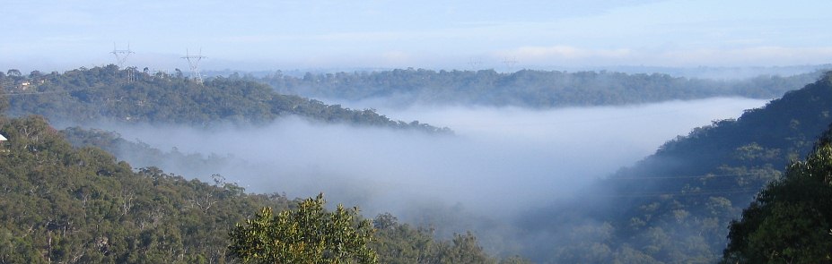
Golly gosh there was lots of fog en route to Mt White this morn'. Imagine if you owned a home down in the Berowra valley. You'd be 'phoning ya neighbour up the top of ya street asking "What sort of a day is it?"
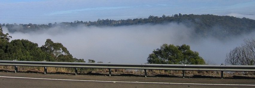
Bazza, Pete C. and BeanCounter turned around at Mt White
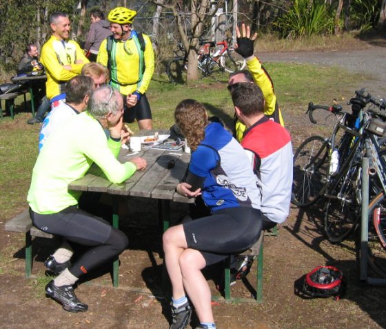
L to R: - down back: Guy 'n
Jean aka DishPig busy in dialogue -
up front: clockwise Richard,
Pacific Pete, Rex aka
The Pimpernel,
Auckland,
Adam 'Ann-Marie.
Approaching Peat Ridge, we passed three Muggs who'd
headed off early, Samurai,
Heineken and
Printer.
If
ya got chores to get down on Sunday arvo ya got to start earlier. However,
prioritizing those chores mid-Winter by sliding
out from under the covers
any earlier than you have to scrape the frost off the windscreen can be tough
for some of us.
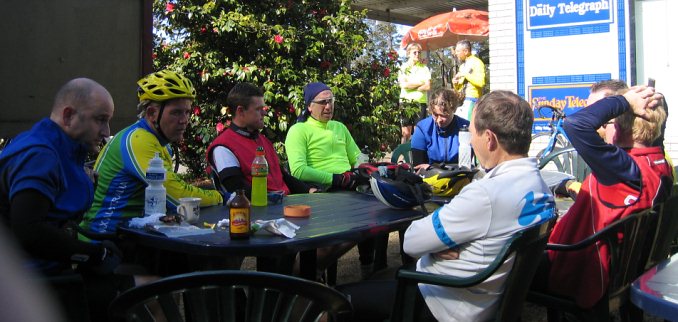
A dozen of the gang enjoying mild sunlight at Peats ridge after 55km
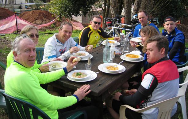
We again all opted for soup of the day at Yarramalong Manor. Alas, the traditional damper wasn't on the menu, so it was bread rolls all-round.
Scribe 23 July '06