www.Muggaccinos.com The Bullsheet
Australia Day long w'end Muggaccinos' "2006 Tour de Victorian Alps" to ride 372km over 3 days preceding Audax Alpine Classic which is on Sunday, 22 Jan '06.
Drive down from Sydney early Wed 18 January and drive back on Monday 23rd.
Muggaccinos’ Sunday rides during Dec/Jan roll out at sparrow fart/cock’s crow to beat the heat and ensure adequate daylight to complete requisite long training rides in preparation for the prima cycling event on the annual cycling calendar - Audax Alpine Classic in the Mecca of endurance cycling country, Vic. Alps.
The Alpine Classic evidences
endurance cyclists from across Aust. flock to
the pristine town of Bright in the foothills of the Vic Alps
twds the end of Jan. for the annual pilgrimage where the splendid
mountainous terrain
proffers entrants in the 200km route four arduous climbs:
* NEE up Towonga Gap 11km,
* NNE up Falls
Creek 29km,
* SWW up Towonga Gap 8km (from
the steeper side); and
* W up Mt. Buffalo 22km.
If you attempt the 200km route, these four marvellous climbs aggregate 3,700m of pedal pumping, quad draining, climbing and an equal number of sheer, heart-throbbing, descents.
Smackers au milieu de this map, at the veritable Bullseye, is the quaint, pristine township of Bright in the foothills of the Vic. Alps.
Bank Teller has attempted the "200km Audax" thrice with two finishes
(best 10hrs 50m in '97) and a DNF after he blew-up, not 'cause he'd gone out
too hard, but 'cause he'd under-prepared. These days Bank Teller spends
3 days in Bright preceding Aust Day w'end cycling the marvellous
climbs in the Victorian Alps and come Sunday, takes pics of
beaut femme butts climbing the steepest section of Tawonga Gap on the return
leg to Bright. Then he rides the 22km route from Bright to Mt Buffalo
'n back.
·
Thurs,
19 Jan
'05, Bank Teller will ride
112km out
'n back
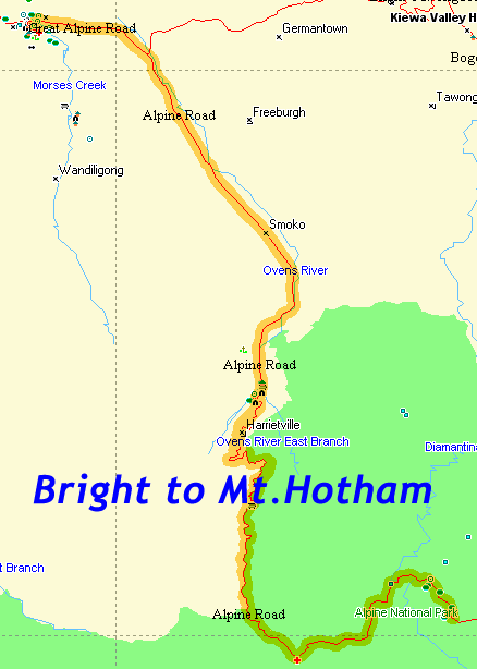
ride SSW to Mt. Hotham,
initially along a pleasant, flattish SEE 25km route to friendly Harrietville.
There is an immediate hard left up a steepish 31km
memorable climb across the spectacular Razorback Ridge
to Mt Hotham (Hotham Heights) known as "the Giant"
- (1,862m above sea
level) in the heart of the Bogong National Park.
After 4.95km of steady climbing you meet The MEG.
Don't let the name frighten you as it is merely a very steep 60m switchback.
From 10.05km to 19.25km you hardly think you are climbing. After 20.85km
you reach Mt St. Bernard and at 23.35km Renee's Lookout where you then
ride across the ridge as you feel as though you are on top
of the world, because all the adjoining mountains to your left and right are clearly
visible, and they all appear smaller
-
31km climbing.
·
Friday 20 Jan - 65km out
'n back ride = 130km due West to Mt Buffalo,
"The Horn" (1,330m) - 22km climbing.
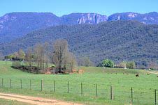
· Sat 21 Jan - 130km out 'n back ride SW to Falls Creek (1,580m) via Mt Beauty and Tawonga Gap (885m) with views across Rocky Valley reservoir and back down the length of the Ovens Valley - 48km climbing. View from Bright twds Mt Buffalo
The above three days' cycling -
(i) ascend 4,467m (1,562m+1,030m+585m+1,280m) from Bright which is 300m above sea level;
(ii) aggregate 372km (112+130+130);
(iii)
require 101km (31+22+48) of gut wrenching, pedal pushing, quad snapping climbing, where
on sections of Tawonga Gap to Mt Beauty and early in the 30km climb to "the Giant"
(Mt. Hotham), you
might be fearful that your front crank is going to snap during one of those
last gasp 'out-of the-saddle' throttles to the floor,
whereupon you could end-up spread-eagled on the bitumen.
Come Sunday, you are welcome to help Scribe take more femme butt pics strategically placed at the steepest section of the Tawonga Gap climb.
Bank Teller has booked, with Pip, a large camp site "up the back" of the below listed Bright Caravan Park which can accommodate 6 people even if they are all in single tents, so 6 tents.
As the Bright motels are booked chockers, below are 3 camp grounds in Bright with prices for pitching your trusty tent:
-
Bright Caravan Park (03) 5755.1141 - centre of town / turn Left at BP garage 100m before bridge - $27 per night for 2 persons on unpowered site with $10 extra for each extra person within that designated camp site
-
Bright Accommodation Park (03) 5750.1001 formerly Green Hills Caravan Park - 3½km East of town centre - $10 per head per night on unpowered site.
-
Bright Riverside Holiday Park (03) 5755.1118 4-10 Toorak Ave Bright. 300m from town. $32 per night for 2 people.
If you are making the annual pilgrimage to Bright between Wed 25 Jan and Friday 27 Jan '06 to -
* climb the marvellous mounts in the Vic Alps; and
* suck some Reds at night,
e-mail ScribePJ@TPG.com.au or 'phone him (02) 9513.1075.
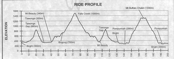
Altitude profile of the Audax Alpine Classic which consists of 3 ride distances from Howitt Park, Bright with 4 starting times.
Directions to Bright (provided by Pacific Pete):
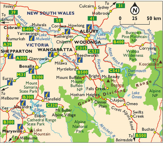
Drive 680km SSW from Sydney thru Liverpool along Hume Highway to Albury on the
Victorian border on an uninteresting freeway route in 7½ hrs. Thence it is
another 90/110 mins to Bright depending whether you take Route1. 2. or 3. below.
Recommend you pull in at the Holbrook Bakery (300m Sth of the big black submarine) which is the first major town Nth of Albury.
Route 1. Simplest albeit longest route is:
Follow Hume Hwy to Wangaratta, then Left onto Ovens Hwy leads to Myrtleford, then Bright.
Route 2. Or 107km (about 30km less) and more scenic:
Drive to Wodonga on Hume Hwy. Left onto Kiewa Valley Hwy on route twds Yackandandah and Myrtleford. Do not turn Right to Yackandandah or Myrtleford, but remain on main road to Mt Beauty and follow this until 3km past Tawonga (which is also 3km prior to township of Mt Beauty) where you turn Right uphill onto the Tawonga Gap Rd up and down Tawonga Gap. At the bottom of the other side of Tawonga Gap turn right into Ovens Hwy for 5km to Bright; or
Route 3. Or about 10km more than 2. above and equally scenic as 2. above:
Drive to Wodonga on the Hume Hwy then exit the Hume by taking the Beechworth Road which is virtually straight on. Drive straight through Beechworth without turning and its another 20km to the Ovens Hwy where you Left and proceed 50km to Bright.
Scribe favours "Route 2." above where after Wadonga follow the Kiewa River Sth twds Mt Beauty. Turn Right into Tawonga Gap Rd to Bright - nestled in foothills of the Vic Alps. After a few days cycling all day and fine wine at night, you won't want to leave.
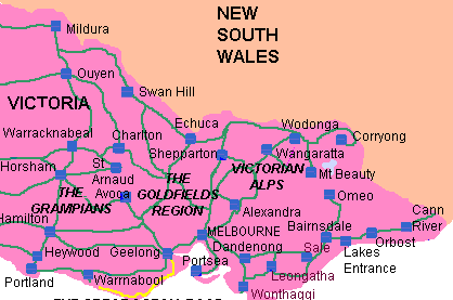
What does the above map show you? Not a lot. It is as boring as batshit driving 680km to the Vic. border and onto Wodonga. However, voila the landscape and scenic beauty increase exponentially the more you drive Sth. into Vic.